 SnapshotChecking image…
The Colorado webcam guide
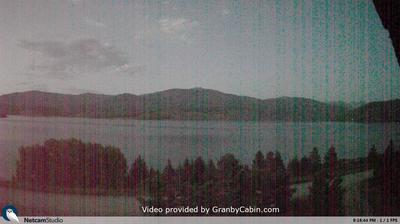
Granby Lake
2 camera views · Snapshots refresh every 60 seconds while visible.
SnapshotChecking image… SnapshotChecking image…
Feed status reflects a migration-time image request, not a guarantee that the image is current. Check the image timestamp. Camera imagery © the credited provider.
About Granby Lake
Lake Granby is the third largest body of water in Colorado. It was created by the erection of Granby Dam, completed in 1950, as part of the Bureau of Reclamation’s Colorado-Big Thompson Project. The lake sits at an elevation of 8,288 feet (2,526 meters), offering boating, camping, hiking, and popular trout/salmon fishing, plus it hosts the largest ice fishing tournament west of the Mississippi.
The area has a high-altitude subalpine climate bordering on a humid continental climate. It’s sees cold, snowy winters. January is the coldest month, with average highs of 20°F (-7°C) and lows of 11°F (-12°C), with sub-zero fahrenheit temperatures common on some nights. While average annual precipitation is low, around 14 inches (36 cm), snowfall is significant, with an average of over 128 inches (325 cm) of snow falling per year, supporting skiing and winter sports. In the summer, it sees a lot of pleasant, sunny days, with average highs in the 60s (teens in °C) to mid-70s°F (roughly 21°C to 24°C), while nights remain cool, often dipping into the low 40s°F (6.7°C to 7.8°C) .
Camera credits & local resources
Granby Lake on the map
Location from the original Keno map embed; it marks the destination, not each camera.
Keep exploring
Original Keno page · Original descriptions © Keno Internet Services.